1933 Mt Whitney Trip
19 Nov
We've heard so many wonderful stories from fans of Mile… Mile & A Half, recalling their own epic adventures in the Sierras, Yosemite and all around the world. The next guest blog was given to us from Dale Berkihiser with a look back at his adventure on Mt Whitney in 1933.
Thanks to Dale for sharing his story, and to Deborah for encouraging him to tell it.
—————-

Dale’s Mt. Whitney Experience
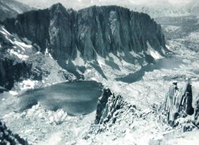
Mt. Whitney is the largest appearing peak toward the right of the picture. This is the east side of the Sierra Range and is almost vertical, compared the gentler slope of the west side, leading into Sequoia Nat’l Park.
You once seemed very interested when I showed you a snap- shot taken of me lying/resting at the top, by the little sign-in box. My buddy, Al, took my picture, and then I took his. This was on Labor Day week end, 1938. There were few people on the trail. This trailhead was at the end of the road above Lone Pine, CA.
We were just 21 years old and were not even hikers. We had very little knowledge of any equipment that might be required. We arrived at the end of the road in mid afternoon, set up a little camp, got comfortable lying on a blanket on the ground and looking up at cliffs soaring up thousands of feet above us on both sides. What a canyon! About 5:30 PM, a wise old Forest Ranger who had driven up to empty trash cans, asked us how we were and what our plans were. When he found out that we intended to hike up to Whitney the next day, he casually mentioned that most hikers who did that started their hike at a place called the “Meadows”, about 5 miles up the trail from we were.
By the time that we closed up our camp, tied sleeping bags and some boxes and junk to our backs, it was almost dark, so we carried along an old fashioned lantern too. At this point I want to remind you that we were in the middle of the Great Depression. Al was lucky to have a job at an automobile parts counter, and I was just a year out of Los Angeles Junior College and was working at Douglas Aircraft in Santa Monica for 40 or 45 cents per hour and as I recall, gasoline was about 12 cents per gallon. I think that people find it hard to believe when I tell them that the population here then was only about 20 to 25 % of what it is now. We were not yet in the “Information Age”, it was much less, and it was more difficult to get. Also there wasn’t the plethora of goods/things that we now take for garneted. For example, there were hardly any stores catering to outdoor sports, amazing!
Back on the 5 mile section of the trail, the moon disappeared; we got lost off the trail once, but briefly, and finished the trek by lantern. We finally arrived at a more or less level area and began stumbling against people in their sleeping bags. I don’t remember what time of the night/morning it was but we found a clearing and crawled into our sleeping bags. We slept to about 8:00 AM, noticed that peoples were gone, except for their sleeping bags & other gear. We made our breakfast and hit the remaining 9 miles of trail with a minimum load on our backs. Probably it was cameras and a can of beans, I don’t remember about water. Above timberline we stopped at several little alpine ponds in solid rock. The portion of the trail below 12,000 feet is on the east side of the range and required about 1500 foot switchback climb.
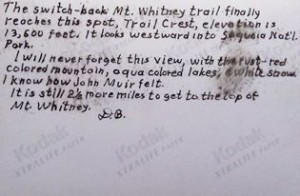
Above that, at the 12,000 foot altitude, we came to a ridge where we looked down into Sequoia Nat’l Park and saw a beautiful view of several steep, & chocolate colored mountains, with snow in the chutes, and aqua colored lakes at the bottom.
I said to myself, “If I ever come up here again, this is as far as I want to go.” I forget the name of this pretty spot.
The rest of the trail from this pretty spot, at about 12,000feet, to the top, “14,496.811 feet” was mostly along the ridge, the backbone of the range. We frequently had a view of Owens Valley to the east. This section of the trail was never steep but it was
very exhausting due to the altitude. We would walk a few yards, stop for breath and almost immediately be able to take on the next few yards.
We arrive at the top at 4:00PM and started back down at 4:15 PM. We had caught our breath saw the stone shelter shack, signed the book, and read the Forestry Service sign. I was impressed with surveyor’s ability to list the altitude carried out to 3 decimal places of the foot.
During our whole hike on the trail, we ran across very few people. It’s not like that today. I hear. We stayed thee only 15 minutes We had brought along water, a can of beans, and two cameras.
After the top we hiked down to the Meadows and stayed one more night there before hiking the remaining 5 miles back to our car, the next morning.
Young and unsophisticated amateurs we were, but we had a memorable trip.
Dale Berkihiser
file:///C:/Documents%20and%20Settings/Dale/My%20Documents/Downloads/Mt.%20Whitney%20photo.htm